Friday, July 22, 2022

CITY OF PINES 2022: HOT CAT SPECIALTY COFFEE

I first heard about Hot Cat Coffee on the IG of food blogger JJ Yulo (nekkidchef) and was quite intrigued about the place. But it did not seem to be the type of place that showed up on online lists of 'best coffeeshops in Baguio' and that sort of thing, which piqued my interest even more. 
 
So on a Sunday afternoon, i literally ran out of North Haven Spa right after my message (ugh, not-so-good experience during this visit) and hoofed it to Hot Cat, as it was closing at 5PM already.   


I was pleasantly surprised that it was located quite centrally (rather near Burnham Park), and i actually stayed nearby during my previous last visit to Baguio a few years ago.  Another pleasant surprise was that the new location of Mt. Cloud Bookshop was right inside the same compound.  
 

Arrived at 4:45PM and i was expecting to see a quiet place with bored staff wiping tables and raring to close shop. But no! The place was bustling with what seemed to be quite a lively bunch of folks, such that i thought i had intruded on some sort of private gathering.


It did feel like everyone pretty much knew one another, and here i was, the anti-social lowlander, sipping my coffee and eavesdropping on the animated convo. Hehe!

The place itself is small, and quiet, almost like it was hiding in plain sight. If one wanted to read/work/hang out quietly, their outdoor seating area is quite conducive for this.

It rained that afternoon, but under fairer weather conditions, i can imagine sitting here soaking in the sunset.

Finally the clock struck 5PM and the staff did start clearing the tables.  The cute intern (who just started in her job a few days earlier) chatted a bit, and i remember she asked me why i was alone. Sadly, grumpy folks like me cannot generate instant witty comebacks just when one really needs them, and i proffered some lame reason. 

The next day (Monday), i was due to return back to Manila. After lunch with S. at Hatch Coffee [refer to one of the earlier posts in this series], i decided on impulse to detour to Hot Cat before going down. 

The place was much quieter this time; in fact, they forgot to flip the "Closed" sign. Whoops :D :D  Here's the friendly owner doing his thing, and a shot of the interiors.


Oh, and of course, i guess it won't be hot cat without the cats!


On a lone sad note, cute intern wasn't around, so my rehearsed witticisms to possible hypothetical questions went for naught ;-D
 

They are located inside the compound at Yangco Road corner Brent Road (literally facing the Brent School campus), and can be found on Facebook (Hot Cat Specialty Coffee) and Instagram (bahaypusa).


Saturday, July 16, 2022

CITY OF PINES 2022: CAMP JOHN HAY FOREST BATHING TRAIL

When one thinks of the former US base Camp John Hay, hiking is not usually one of the first activities that come to mind. It's more of the luxurious accommodations at The Manor, the golf course designed by Jack Nicklaus, the restaurants, the duty-free stores...heck, the mini-golf course even. 

But i had stumbled upon a blog that talked about forest hiking trails inside CJH. And there apparently were two of them. I'm not much of a hiker, but this trip was supposed to be a relaxing one away from maddening crowds and tourist spots; and despite initial apprehensions ("ummm, where does one pee if one needs to pee? what if i encounter a huge snake blocking the path? may cellphone signal ba dyannn?"), we said let's gooo!

The shorter, more popular trail is known as the Eco-trail, and can be accessed across Le Monet Hotel on one end, with its other end near Gate 3, the camp's former main entrance.

Our activity today was to walk along the other trail, called the Yellow Trail. This is a longer, winding hiking trail through the pine forest on the southern and eastern regions of Camp John Hay.

The Yellow Trail has been renamed by the Dept of Tourism, and is now known as the Camp John Hay Forest Bathing Trail. According to the site Ikot.PH, this was opened to the public in November 2018. The underlying idea was to introduce the  practice of shinrin-yoku as a tourism and recreational activity in Baguio.

You might ask, what's this?  Well, i will explain not-so-grumpily: shinrin-yoku literally translates to ‘forest bathing’ (after the Japanese words shinrin, which means ‘forest’; and yoku, which means ‘bath’). 

Basically, it is the concept of taking a recreational trip into the forest for meditation, relaxation, therapy, and well-being. There have been some anecdotal studies showing how this is helpful in lowering blood pressure, boosting one's mood, and the like.

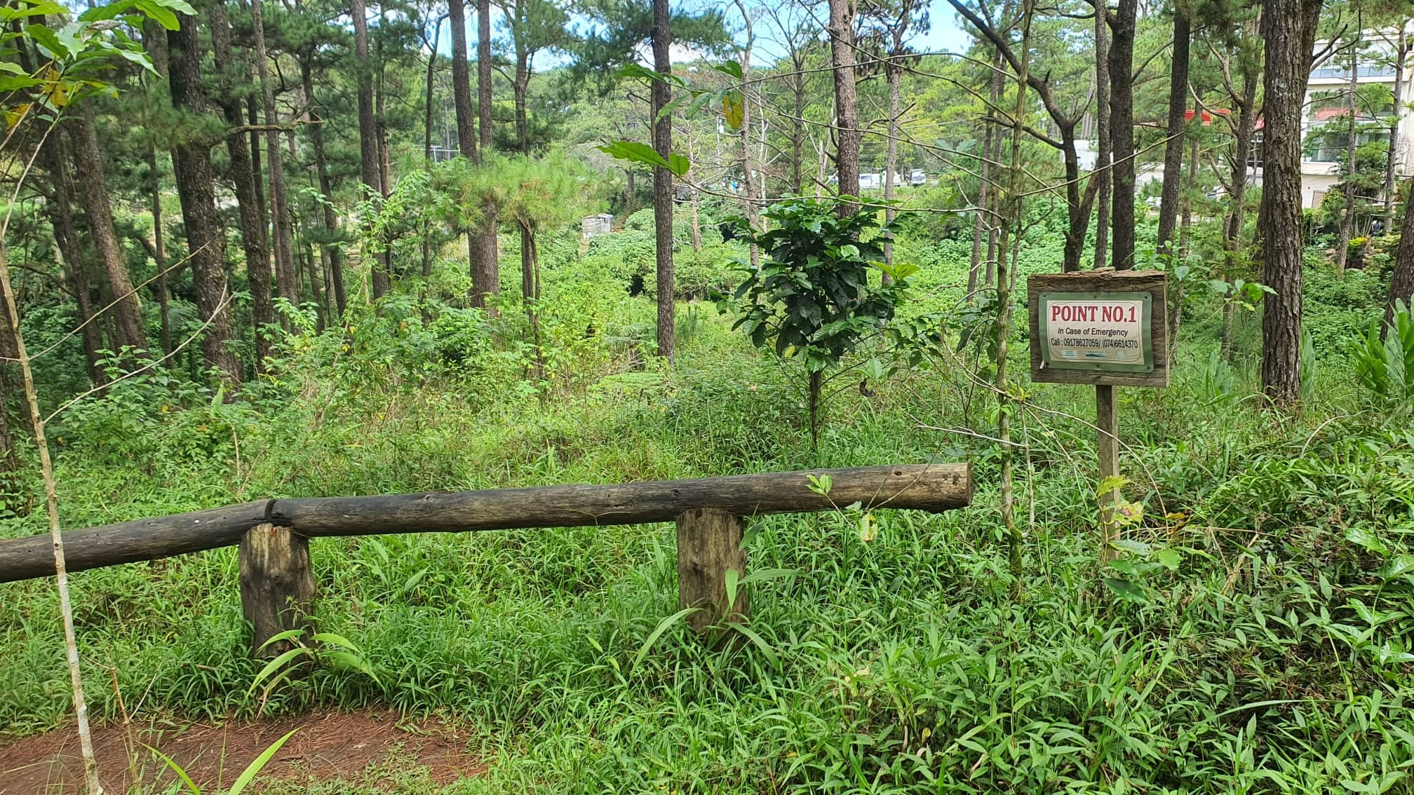
After some searching, we found our starting point! Above is the Torii marking one end of the Forest Bathing Trail (i.e. Point 1). It is situated on the far end of the parking lot on the western slope of Scout Hill.

 Here below is a list of Do's and Dont's before one enters the trail.

 
The forest bathing trail is divided into 9 checkpoints, with markers for each point. So off we go! (Aptly, the song 'No Turning Back' by Gui Boratto was playing on my mind) 


 Not sure what the purpose of this one below is: 

 
Meandering at a leisurely pace, with silence except for the faint chirps of birds, we reached Point 2 shortly. 
 
 
This is one of the flatter, more wide-open portions of the trail. 
 
 
We bumped into this kid riding his bike along the trail (despite the rule expressly forbidding it). Thankfully, he turned back soon after. It would have been foolhardy to bike at the narrower, cobbled parts of the trail where one's frantic screams while dropping down the precipice will surely echo like a chamber of hellos hello hello hello :-D
 

Oh look, wind chimes! Nice! I wondered briefly what it would be like to be on this trail with an overcast gray sky, and a fierce wind blowing amidst the rumbles of an impending storm, just to hear how the wind chimes would sound like.  Sana next time! (Oh wait, there might not be a next time ;-D)

 
We crossed paths with other folks walking the trail, coming from the other direction (they started at the opposite end, Point 9); and there is something about being relaxed and being outdoors that makes one more convivial, and invariably 'hellos' are exchanged amongst fellow hikers.  

This guy (see that person in blue?) was jogging briskly on the path, and came from behind us. Woww!

 
Still some old vestiges of the former owner remain. Check the sign "Private Property: United States of America" that have been left untouched. 


We eventually reached the midway point, i.e. Point 5. It is distinguished by a paved road and a guard crossing ("Residence: United States of America"). The guardhouse was shut, and looked like it had not been in use for many years, if one were to go by the cobwebs attached to its door.


In some parts (like below), the path is less delineated; and one has to really watch one's step. 


Here and there, there were folks on the trail who had the time and talent to stack rocks on top of one another, with pretty results: 


This one below was my favorite. Nice formation, with a killer view point to boot. It was an ideal pit stop/resting place to just take it all in. Remember, the idea of forest bathing was to walk/hike leisurely....this is not meant to be The Amazing Race. 

 
Signages (both the new 'Forest Bathing Center' and old 'Yellow Trail') along the way, reassuring one that one has not gotten lost hehe! 


Obligatory hiking photo of moi, lest my friends think i'm too lazy to actually hike and am faking all of this. LOL :-D 


Point 8, already!! Okay! We are nearing the final leg of our journey!


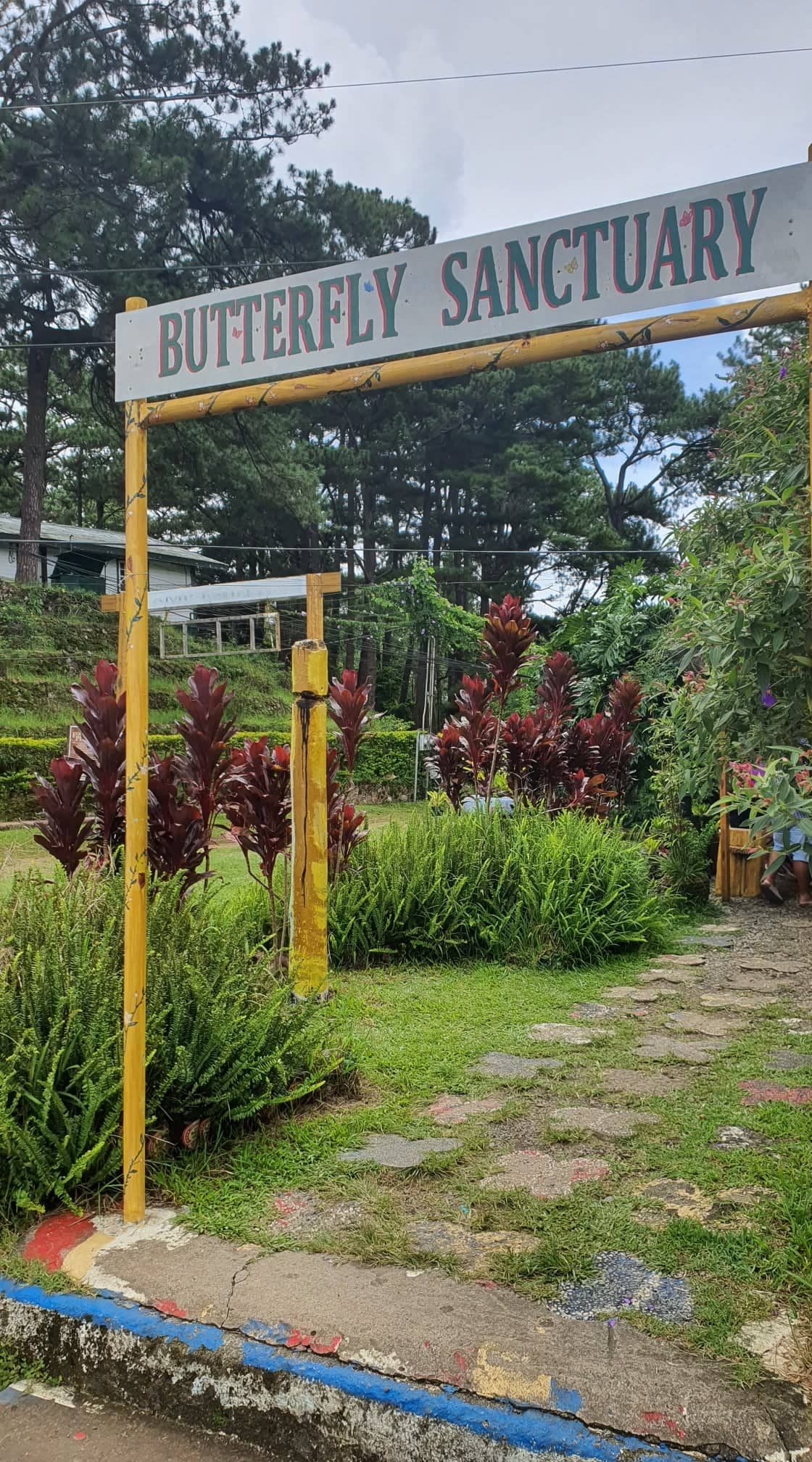
We passed by a gymnasium-like structure, which seemed to be the zipline facility of CJH. Thereafter, there was a narrow, muddy stretch of path. Once you see this signage of the Butterfly Sanctuary, the end of the path will literally be in sight.  
 

And this below is the sign that you have completed the forest bathing trail....except that the signage seems to be missing (stolen? being repainted?).

But don't worry, beside it is the Butterfly Sanctuary, and they have a proper sign. Right next to it is the Lone Star Cafe, and fronting it is the open area used for go-karting. 


And just like that, after walking for 1 1/2 hours, we finished the trail! Emerging back to civilization (exag :D).

Mercifully, Point 9 lies just a few hundred meters away from our starting point, Point 1; and we were able to get back to our car in no time. Not before partaking of Baguio's famous strawberry taho from an ambulant vendor, of course. 

A fitting denouement to our forest trail adventure, no? (actually i couldn't think of any other way to end this blog post sorry not sorry)


POSTSCRIPT: Some comments and observations about the Forest Bathing Trail: 

a)  When we reached Point 5, we realized we somehow missed the markers for Point 3 and 4.  Likewise, upon reaching Point 8, we wondered where the markers for Point 6 and 7 were. Either we were not paying attention (not likely) or walking too fast (duh), but it just seemed weird to have missed seeing them.

b) To get the full experience, I really suggest to put away one's phone and watch, and resist the urge to check either of them.  There's enough time to do that later on. 

c) I had read online that there would be some sort of registration area, or at least, a person with a log book, even though the trail is free. But no. One just shows up and starts walking. 

d) From my POV as a seldom hiker, there were some parts of the trail that surely could use a handrail or two, for safety purposes. [Paging DOT!]

e) Indeed, no toilet facilities anywhere along the trail. Not that we expected any.  But one of us joked that a sari-sari store (selling softdrinks and Piattos and Juicy Fruit gum) in the midst of the path was the type of Pinoy thing that would be a cool and rather absurd thing to happen! :-D


For a full detailed account from a Baguio local, please check out: 

https://phmillennia.com/along-the-forest-bathing-trail/

Tuesday, July 12, 2022

CITY OF PINES 2022: MT. KALUGONG KAPE-AN

So here we are, climbing the uneven rocky pathway up to one of the best features of Mt. Kalugong ecopark, the resident coffee shop Kape-an. 

 
It's a humble wooden structure on the outside, but the interiors are really nice and spacious. 


First thing you see is a wooden board, with menu items. There's also a glass display of the cakes ("kek") available. 

Wooden interiors provide that native, rustic feel that's conducive to chilling out (literally, especially if it's windy outside)


I would give a lot to sleep so soundly as this cute doggo here ;-D


I ordered the crispy chicken fillet burger, which proved to be absolutely juicy and scrumptious. This beats McChicken at any time of the day in any altitude!!! 

 I resisted from ordering coffee, and instead went for the Strawberry Milkshake (hey we are in Baguio....err, La Trinidad diba). Very very good, i could drink this every day.


And here is the best feature yet of Kape-an: They have this balcony/view deck, which provides an all-encompassing view of La Trinidad.


Ah! Just glorious, isn't it?  Yup, that's the strawberry farms right there!


Kape-an is the perfect place to relax and have a bite to eat, before one leaves and hikes back to the jump-off point and returns to Baguio. 

The only downside i can think of is that their Wi-fi is not free. They charge PHP40.00 for 2 hours use (for 2 devices). 

Please check their Facebook Page 'Mt. Kalugong Kape-an/Cafe' and Instagram 'kalugongkapean' for menu and updates.

Sunday, July 10, 2022

CITY OF PINES 2022: MT. KALUGONG CULTURAL VILLAGE

I first got wind of Mt. Kalugong when a friend of mine posted photos about it on Facebook last December. Intrigued, i snooped around a bit, and realized it was located around 30 min away from Baguio city. 

As i have been to Baguio many times, and didn't intend to do touristy stuff like boating at Burnham Park nor kabayo-ing at Wright Park, i thought this seemed the perfect activity to try.

So it was that on one hot, muggy day, we set off for Mt. Kalugong Cultural Village.

For background, the name 'kalugong' comes from the local term for 'hat'. Apparently, the rock formations at the peak look like a hat when viewed from below. 

To get there: Ride a jeep bound for Camp Dangwa or Upper/Lower Tomay (this is the same jeep that goes to the strawberry farms in La Trinidad). Alternatively, just as we did, we took a taxi.

Make sure to tell the driver to drop you off at Brgy. Cruz. This is well-known to PUV drivers, and the road is quite a busy one with many commercial establishments; so finding a jeep or a taxi going back to Baguio afterwards will not be a problem. 

This is the jump-off point, so once you see this, you are in the right place: 


At the corner is where Benguet Memorial Service is located. But hey, don't let any macabre thoughts creep into your mind :-D  To my knowledge, no one has expired yet while going up to Mt. Kalugong and needing memorial services! Here's a closer look:

The road going up is well-paved, and winding in some parts, and steep. Make that very steep. We stopped periodically to drink water and catch our breath. 

Signages along the way, providing encouragement :-D


Eventually, the paved road reaches a private subdivision gate (take note the gate is closed from 6PM to 6AM). Only a few houses built so far. 


I realized this is one other way of getting to Mt. Kalugong: Rather than huffing and puffing from the jump-off point, one can actually bring a private vehicle and go up the paved road, and park along the road of this very quiet subdivision.  (Or take a taxi and pay the driver extra to bring you up to this point) 

This way, one cuts out most of the hike (and the huffing and puffing). But of course, slackers like me do not take the easy way out! Laban langggg! **puffs chest out in fake, vainglorious display of bravado**
 
(My friend S. told me later on that no need for an SUV, her Honda Jazz could manage the steep road)
 
 
Okay, so this is the end of the cemented road inside the subdivision. Another encouraging sign that "You are healthy"!! Woohoo!!! 

At this point onwards, one has to walk up going to the cultural village. We turned left and continued going up the foot path, which was narrow and uneven and rather muddy. Thankfully, one can hold on to the makeshift fence made from bamboo poles (watch out for the barbed wire, though)


Here's a short clip for better appreciation of the lovely view, as well as what the steps going up look like: 
 
 
 And after more huffing and puffing, we reached the ecopark. Yes!! [fist pump]
 

There is an environmental fee of PHP100.00/person (it is a private property, after all).   

 
So nice this place! Cool and tranquil.


Below is a campsite area, wherein one can actually stay overnight. 
 
  
Here's another look at it, from the opposite direction:


 In the next post of this series, we'll check out where these steps (note the ingenious of used rubber tires) lead to [hint: a coffee shop and some awesome views].

If you're interested in going, please check their Facebook Page 'Mt. Kalugong Cultural Village' for updates. 

Practical tips: Bring water, and make sure to wear proper footwear (hiking shoes like Merrell). 

Bonus: Check out the Youtube video of local guy The Torogi Wanderer, whom i reached out to prior to going; and he was very helpful with tips.